
Last week during a visit to my in-laws' home in West Virginia, I took a day trip to visit some old friends in Cumberland, Maryland. I lived in Cumberland back in the 1970s, and it is still one of my favorite places. Nestled in the hills of the Alleghenys, Cumberland is a very historic city. It was home to the headquarters of General George Washington during the American Revolution. It was also a major transportation hub in the early days of the United States, when it served as the western terminus of the famed Chesapeake & Ohio Canal, the eastern terminus of the National Road (now US 40), which ran from Cumberland to Columbus, Ohio; and eventually to Vandalia, Illinois. Cumberland is also a major rail center for the CSX (formerly B&O, C&O, and Western Maryland) rail line.
While I got to Cumberland too late to take any pictures there, my wife and I stopped along the way to have lunch at one of our favorite places. That place is Penn Alps in Grantsville, Maryland, located west of Cumberland in Garrett County. The grounds of Penn Alps contain the restaurant, an artisan village, and the old Casselman River bridge, seen in the photo above. Built in 1813, it was the longest single-span stone bridge in America at the time. It was actually made tall enough for the C&O Canal traffic to go under it, but the advent of the railroad meant the canal was never extended west from Cumberland. The bridge is also at the site where Generals Washington and Braddock crossed in 1755 on their way to Fort Duquesne (Pittsburgh, PA). An interesting side note: The historical marker references "Castleman's River", while all other signs in the area call it "Casselman River".
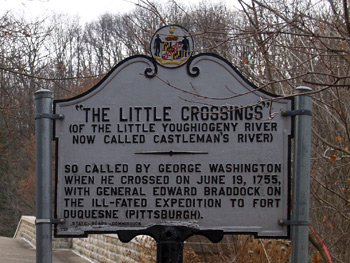 lunch at one of our favorite places. That place is Penn Alps in Grantsville, Maryland, located west of Cumberland in Garrett County. The grounds of Penn Alps contain the restaurant, an artisan village, and the old Casselman River bridge, seen in the photo above. Built in 1813, it was the longest single-span stone bridge in America at the time. It was actually made tall enough for the C&O Canal traffic to go under it, but the advent of the railroad meant the canal was never extended west from Cumberland. The bridge is also at the site where Generals Washington and Braddock crossed in 1755 on their way to Fort Duquesne (Pittsburgh, PA). An interesting side note: The historical marker references "Castleman's River", while all other signs in the area call it "Casselman River".
Just to the south of the Casselman bridge are two other bridges built over the years. First is the US 40 bridge, followed by the Interstate Highway 68 bridge over the Casselman River.
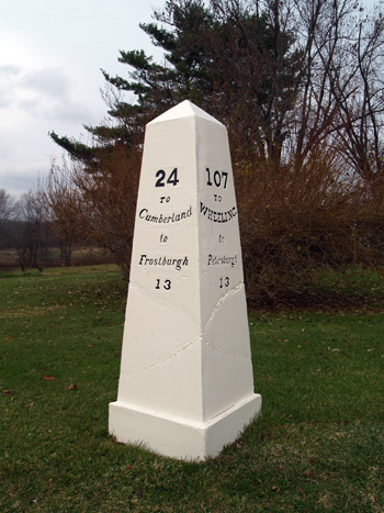 As I mentioned above, US 40 follows the route of the old National Road. Milestones were placed at points along the road to tell travelers the distance to major points. Not far from the Casselman River Bridge in Grantsville is one of these historic cast iron mileposts. A similar one that sat six miles to the east is now on display at the Smithsonian. CLICK HERE to read more about that one. According to the Smithsonian, these markers were cast in the foundry of Major James Francis, at Connellsville, Pennsylvania. They were put in place in the late 1830s or early 1840s.
If you would like to see a display with a photo of another similar marker in a photo from the early 1900s, you can download a PDF of the Maryland display for where the National Road left Maryland and entered Pennsylvania by CLICKING HERE.
There is so much history in the entire Western Maryland, Pennsylvania, and West Virginia area, that it is well worth making a trip there if you can.